ConnectField
The mobile app for data collection and field operations
ConnectField is a mobile app for data collection and field operations developed by Dotic. It enables technicians and field teams to carry out surveys, investigations, audits, inspections, asset inventories and maintenance operations using a smartphone or tablet.
The app allows users to geolocate assets, enter information in task-specific forms, take photos, create or edit GIS features and work offline. The collected data can then be synchronised with ConnectServices to be centralised, checked and used in a Web GIS.
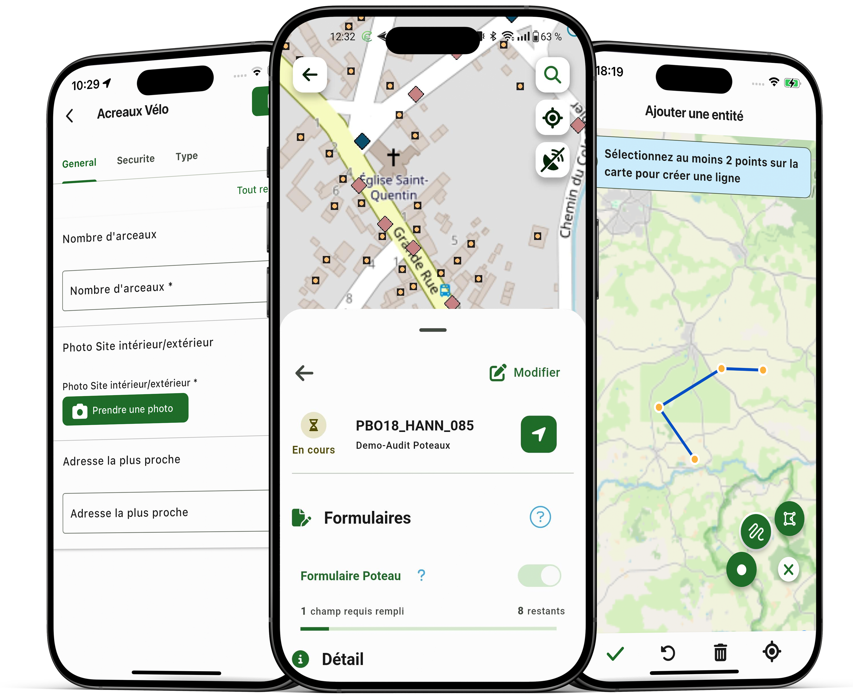

ConnectField supports teams working on networks and infrastructure assets. In the field, they can view, collect and update data relating to equipment and technical sites, including in areas without network coverage.
What is a field data collection app?
A field data collection app enables mobile teams to record, document and update information directly at the work site.
ConnectField combines this data collection with GIS mapping, geolocation, task-specific forms, photos, offline working and synchronisation with the office. The resulting data is structured and ready to use, without re-entering it.
This focus on operational needs translates into practical priorities:
- Quick to learn, without complex training.
- A field-focused workflow (data entry, photos, offline mode, dashboard, map viewing, in-app navigation…).
- Operation and usability, proven by many technicians and field workers, that facilitate deployment and adoption by field teams and help organisations plan costs more effectively (training, support, configuration, operation).
Use cases: what ConnectField enables teams to do in the field
Audits, inspections and field surveys
With ConnectField, your teams carry out geolocated, documented audits: findings, classification, photos, comments, statuses… The aim is to obtain an accurate, consistent view of field conditions, without re-entering data.
Network maintenance and field operations
ConnectField makes maintenance easier: locate an installation, record a fault, document a job, classify an issue and track its resolution. Integration with the Web GIS platform improves continuity between the field and the office.
Asset inventories and asset register creation
When a network changes, or the initial reference dataset lacks accuracy, it may be necessary to create features or reposition existing ones. The feature creation function (points, lines, polygons) supports asset inventories, issue surveys, position corrections and siting.
Works monitoring and defect resolution
With ConnectField, site monitoring becomes more straightforward: structured observations, photographic evidence, statuses, progress and consolidation in a single, reliable reference dataset.
How does ConnectField work?
- Prepare the assignment: field operations are configured and planned in ConnectServices.
- Assign the job: the assignment is sent to the relevant technician.
- Work in the field: the field worker consults the map and relevant information.
- Collect data: they complete forms, add photos and create or edit the GIS features they have worked on, online or offline.
- Synchronise: the operator sends the collected information to ConnectServices as soon as a connection is available.
- Check and use the data: data is centralised, verified and analysed in ConnectServices.
Key features designed for efficient fieldwork

Geolocation: improve the reliability of field operations and data quality
ConnectField is a geolocation-enabled mobile app: users can find their position, locate a feature or enter information that accurately reflects field conditions. Geolocation also helps make field operations more reliable and provides an accurate view of where data was collected.
Offline mode: keep working without interruption
In the field, connectivity is not guaranteed. Offline mode enables teams to work in areas with limited or no coverage and ensures continuity of field operations.

Photo evidence: document and share field observations
Taking photos directly within forms provides objective evidence of findings, facilitates validation and ensures transparency in exchanges.

GIS feature creation: inventory, reposition and classify field assets or issues
Feature creation (points, lines, polygons) supports siting studies, inventories at the pre-project stage, position corrections, issue surveys and the completion of inventories. Combined with the data editing function in ConnectServices, this feature enables teams to create a mapping reference dataset that can be edited, updated and shared.
Geolocation: achieve centimetre-level accuracy with suitable GNSS equipment
Compatible with professional GNSS receivers, ConnectField supports high-precision surveys, down to centimetre-level accuracy depending on the equipment and measurement conditions, including to meet Class A georeferencing requirements.
Task-specific forms: structured, reliable data entry

In-app navigation: optimise field operation times
AI: simplify data entry and improve the reliability of field checks
Depending on the features deployed, ConnectField can integrate artificial intelligence tools to assist certain field operations, including automatic label reading and checks of regulatory height requirements at technical sites.
ConnectField and ConnectServices: what is the difference?
ConnectField — the mobile field app.
Technicians view maps, carry out surveys, complete task-specific forms, take photos and update GIS features, online or offline.
ConnectServices — the Web GIS platform for the office.
Managers prepare and assign jobs, centralise synchronised data, check its quality, monitor activity and use the collected information.
ConnectField and ConnectServices are two complementary solutions developed by Dotic: ConnectField enables teams to collect and update data in the field, while ConnectServices enables them to centralise, view, check, use and report on it in a Web GIS.
This field-to-office continuity reduces repeated data entry, harmonises practices and makes it easier to monitor field operations.
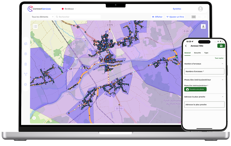
ConnectServices can complement ConnectField by cross-referencing field data with other geographic or environmental data. This centralisation facilitates coordination and prioritisation of field operations, particularly during events affecting multiple infrastructure assets.
Who is ConnectField for, and which infrastructure assets does it cover?
ConnectField is designed for teams that physically work on equipment, networks or assets: field technicians, operations staff, inspectors, auditors, engineering consultancies, contractors, subcontractors, network managers and local authorities.
The app can be used on telecoms and fibre optic networks, water and wastewater networks, electricity networks, as well as roads, urban equipment and other geolocated assets.
How do you choose a field data collection app?
A field data collection app should be chosen according to actual working conditions and the data to be produced. The main criteria are offline operation, customisable forms, GIS mapping, GPS or GNSS geolocation, photo capture, feature creation and editing, field operation tracking and synchronisation with office tools.
ConnectField covers these needs in a field-to-office workflow linked to ConnectServices. The final choice depends on the operational process, expected accuracy, infrastructure involved and checks to be performed.
Public sector organisations: find ConnectField on these platforms