ConnectControl
Quality control software for infrastructure data
ConnectControl is quality control software developed by Dotic to check, validate and improve the reliability of geographic data on networks and infrastructure. It detects anomalies and checks data compliance with reference frameworks and business rules, making it easier to correct data before integration.
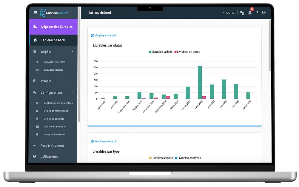

ConnectControl scales up checks on data flows associated with infrastructure construction and operation. It is designed for operators, network operating organisations and managers of telecommunications, water or electricity networks who want a reliable geographic reference dataset.
Why check the quality of infrastructure data?
GIS data quality control involves checking data structure, completeness, compliance with a model, and geographic or business consistency. Performed before integration into the reference dataset, it helps you to:

- Improve the reliability of operations and decisions.
- Validate deliverables before integration.
- Reduce late corrections.
- Track quality over time.
Features for checking, correcting and reporting
Scale up checks on incoming data flows
ConnectControl automates quality control of your incoming data flows (projects, updates and historical data recovery) to check consistency with existing data and compliance with your standards.
Analyse, visualise and address anomalies
Detected anomalies can be viewed clearly and in detail through integrated map and schematic views. This makes them easier to understand, prioritise and correct, while streamlining discussions and information sharing.
Apply geospatial standards and business rules
Data submissions are made through the platform and their history is retained. ConnectControl applies and checks the rules defined by geospatial standards as well as the organisation’s own business rules. It also checks attribute completion rates, categorises anomalies and shares results.
Track changes in network assets
ConnectControl lets you view changes in your network assets across versions of deliverables or at a given point in time through an inventory of deployed components. For this purpose, 60 analytical indicators are available to generate quantities for infrastructure elements.
Check data compliance and consistency
Validate data before integration
ConnectControl checks data completeness, compliance with the expected model, and geographic or business consistency before integration into the target information system.
Generate clear inspection reports
FTTH focus
Proven over many years in the fibre optic sector, ConnectControl is the reference solution for certifying data from French public initiative networks (Réseaux d’Initiative Publique), recognised by both the largest private operators and public institutions.
Dotic, developer of ConnectControl
Dotic develops GIS software for collecting, checking and using infrastructure data.
Request a demoPublic sector organisations: find ConnectControl on these platforms

How does ConnectControl work ?
- Import or submit the dataset.
- Select the reference framework and rules.
- Run automatic checks.
- Visualise and assess anomalies.
- Correct and check again.
- Compare anomalies.
- Validate and share the report.
Which errors can ConnectControl detect ?
Depending on the configured check grids, ConnectControl can identify missing data, structural errors, geographic or business inconsistencies, incorrect topological or attribute relationships between objects, and non-compliance with a model or reference framework. Anomalies are then grouped and prioritised to make them easier to address.
Compliance, consistency, geospatial standards and business rules
Compliance checks adherence to a format, model or standard. Consistency checks for the absence of logical, geographic or business contradictions. Data can therefore comply structurally while remaining inconsistent.
ConnectControl can use geospatial standards such as GraceTHD, StaR-Eau, StaR-Electt or RecoStaR when suited to the project, as well as the organisation’s own rules. Find application contexts on the pages about water networks and electricity networks.
How can infrastructure data collected in the field be validated ?
To validate infrastructure data collected in the field, you need to check its completeness, compliance with the target model, and geographic and business consistency before integration. Anomalies are corrected, then a further check confirms that the deliverable meets the standard’s requirements.
ConnectField collects and updates data in the field; ConnectControl then checks its quality and compliance.
Who is ConnectControl for, and for which networks ?
ConnectControl is designed for operators, network operating organisations, infrastructure managers, local authorities, engineering consultancies, and GIS or quality managers who need to receive, check and improve the reliability of network data.
The solution can be used for telecommunications and FTTH infrastructure, water and wastewater, electricity networks and other infrastructure where the necessary models and rules are available. For specialist inspections of telecommunications networks, also see the telecom audit software.
ConnectField, ConnectControl and ConnectServices: what are the differences ?
The three software products in Dotic’s Connect range cover complementary stages:
- ConnectField collects and updates data in the field.
- ConnectControl checks its quality, compliance and consistency.
- ConnectServices centralises, visualises, edits and uses data in a Web GIS.